
Experience a National Recreation Trail in Arkansas
National Recreation Trails are recognized as exemplary trails of local and regional significance and there are more than 1,200 designated trails in all 50 states. Arkansas has a plethora of NRTs that range from short, accessible paths to trails for those that seek an arduous adventure.
Whether you’re looking for a path less traveled or just a stroll to soak in the great outdoors, a place to discover nature and wildlife or to enjoy fitness and fun, here are some Arkansas NRTs worthy of your time:
Northwest Arkansas
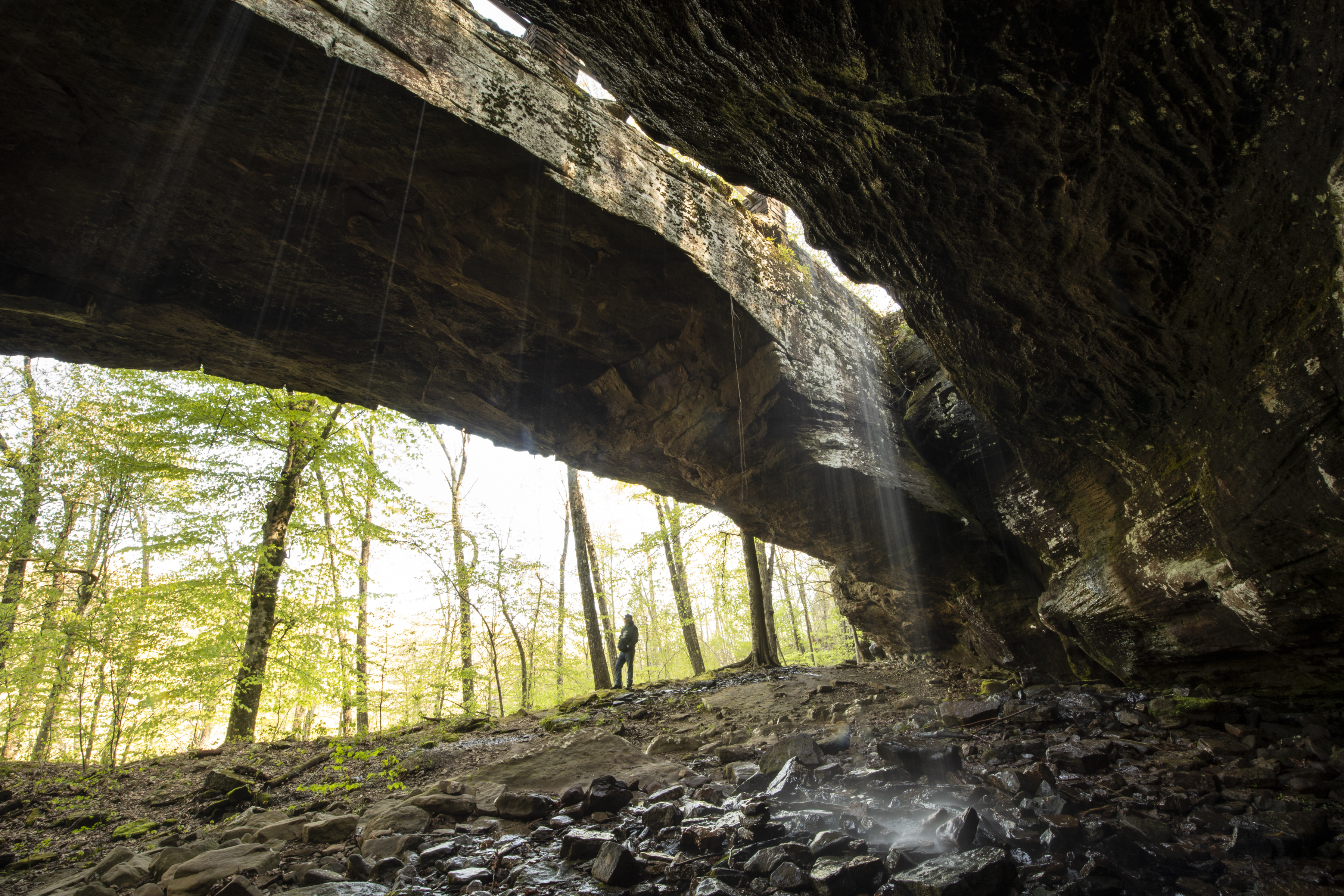
Alum Cove Natural Bridge Trail — 1.1 miles
Located in Newton County, this loop trail passes a nice bluff line and one of the largest natural rock bridges in this part of the country. Look for the wild magnolias and free roaming goats.
Devil's Den Self-Guided — 1.1 miles
Located at Devil’s Den State Park, this is a popular trail that gets high use. It has a natural surface and is considered moderately strenuous due to elevation changes, numerous rock steps and uneven surfaces.
Yellow Rock Trail — 2.5 miles
Hike 300 feet in elevation to one of the best views in Devil’s Den State Park atop the Yellow Rock, where you’ll have an unobstructed view of the Lee Creek valley. Along the way you’ll also see cedar glades, interesting rock formations and the first structure built in the park. (Do you know what television series was filmed in part at this location?)
Ozark Highlands Trail — 165 miles
Spanning most of the northern half of the Ozark Mountains from Lake Fort Smith State Park to the Buffalo National River, this trail is popular for backpacking, diverse landscapes, and scenic beauty.
Springhill Mountain Bike Trail — 10 miles
This winding trail consists of three loops and is used by hikers and bikers. Part of Springhill Park, it lies just outside of Barling, and is a close drive into Van Buren and Fort Smith.
River Bluff Nature Trail — 1 mile
This self-guided trail overlooks Ozark Lake from atop the high bluffs and leads to an overlook shelter. Displays at the overlook describe the history of the area.
Bridge Rock Trail — 1 mile
The trail winds along a rugged northwest slope overlooking a portion of Shoal Creek and passes under a rock arch. There are three routes but the total length is one mile for the entire trail. Look for information trail markers along the way.
Summit Park Self-Guided Trail — 1 mile
One of the oldest trails in the state, this trail began as a footpath for Summit Park Hotel guests and became a more elaborate trail built by the Civilian Conservation Corps in the 30s as part of Mount Nebo State Park, the second oldest park in the Arkansas State Park System. It’s moderate to strenuous and has 12 historical points of interest.
Old Post Road Mountain Bike Trail — 8.71 miles
Located in Old Post Road Park, this trail has a series of 12 interconnecting loops. The trail has beginner, intermediate and advanced sections and the park has traditional amenities.
Bona Dea Trail — 5 miles
Located in Russellville, the Bona Dea winds through 186 acres of wetland habitat, where you’re bound to see wildlife. It also has exercise stations.
Prairie Creek Jogging Trail — .25 miles
This trail is a quarter-mile asphalt fitness trail on flat terrain.
North Central
Pigeon Creek Trail System — 12 miles
This backcountry trail system is popular with mountain bikers, hikers and photographers and provides access to the scenic areas of Norfork Lake.
Robinson Point Nature Trail — 3 miles
From limestone bluffs to cedar glades, this trail is a splendid hike through nature that climbs a buff high above Norfork Lake.
Dripstone Trail — .4 miles
Located at Blanchard Springs Cavern, this trail is underground on a lighted, paved walking path through two huge rooms filled with sparking flowstone, columns, stalactites, stalagmites, and delicate soda straws. Unlike the others, there is a cost to this trail, which includes a guided tour.
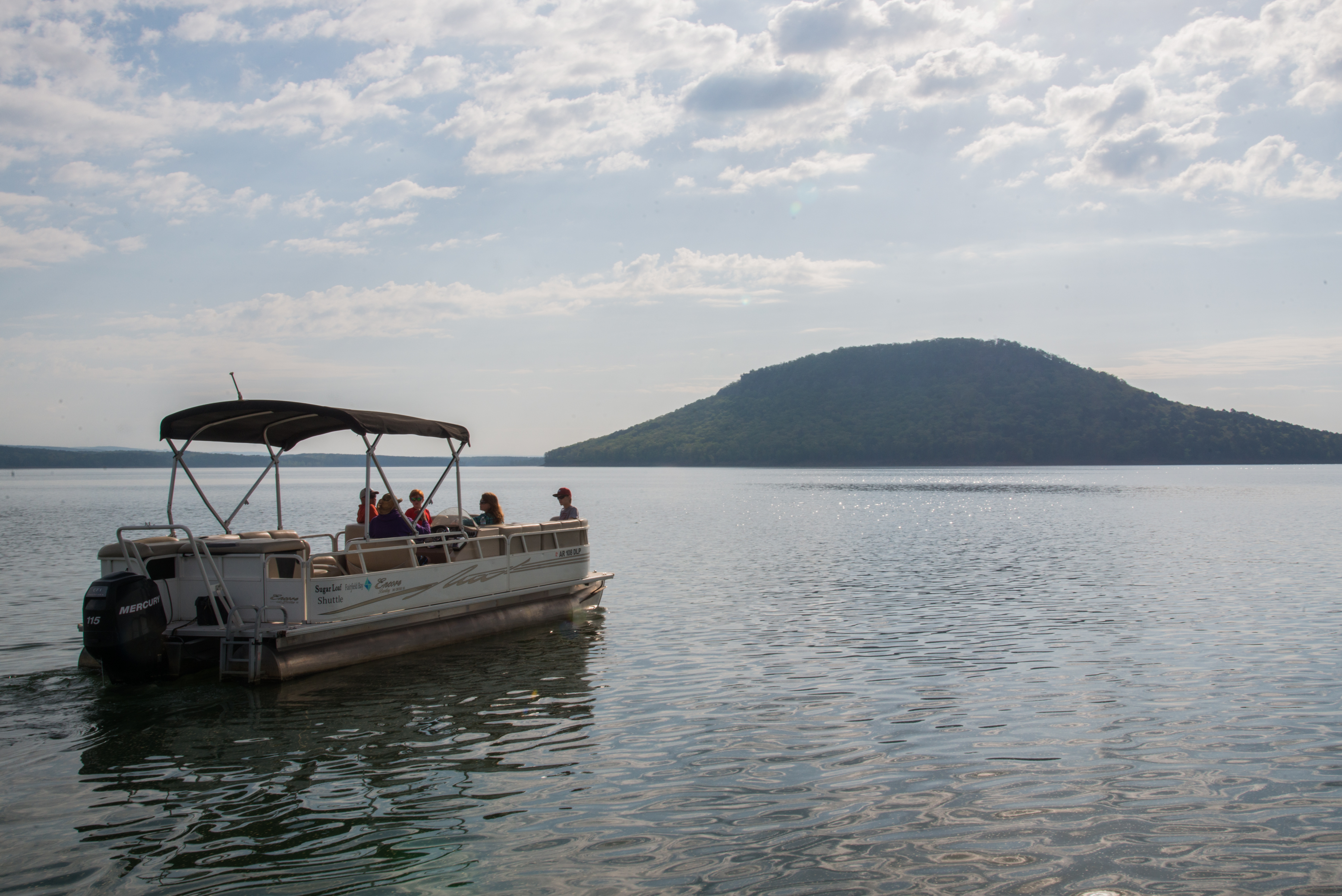
Sugar Loaf Mountain Nature Trail — 2.1 miles
This unique trail is on accessible by boat. It’s located on Sugar Loaf Mountain Island, which rises 540 feet above Greers Ferry Lake and 1,002 feet above sea level at the highest point. Reach the top for an unequaled panoramic view of the surrounding lake and Ozark Mountain terrain. You can catch a ferry at Fairfield Bay Marina. (Read about the two mountains with the same name here.)
Buckeye Trail — .4 miles
The 660-foot long Buckeye Trail was constructed to provide a quality trail experience that’s accessible to wheelchairs. Its smooth, level surface is easy to walk as well.
Mossy Bluff Trail — .8 miles
This trail winds along a wooded bluff with the overlook at the trail's end offering a scenic panorama of Greers Ferry Dam, the National Fish Hatchery, and Little Red River.
Josh Park Memorial Trail — 1.9 miles
The trail is used by campers in Dam Site Park, as well as hikers, walkers, runners, bicyclists, and nature enthusiasts visiting the area.