Caddo Valley
Caddo Valley is a town in Clark County located halfway between Texarkana and Little Rock. Clark County was founded on December 15, 1818, as part of Missouri Territory and was named for Missouri territorial governor William Clark of the Lewis and Clark Expedition. The county is part of the Ouachita Mountains and the Gulf Coastal Plain, making the area prime for farming and hunting.
Before Europeans arrived American Indians, particularly the Caddo Indians (of which the town is named after), lived in the area. The area was known for its heavy forests, plentiful game, rich soil, and clear streams. According to archaeological evidence, the Indians stayed quite a bit in the area. Henderson State University in Arkadelphia hosts one of the largest collections of Caddo Indian pottery in the world.
Caddo Valley was incorporated in 1974. The town is somewhat of a crossroads as both rivers and highways converge in the small town. Two rivers cross paths here: The Caddo River and the Ouachita River and the community is located at the junction of Interstate 30, Highway 67, and Scenic Highway 7. The town is 2 miles north of Arkadelphia and DeGray Lake Resort State Park is around 3 miles away. Hot Springs is around 40 miles away.
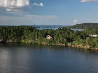
The strip of businesses that line Hwy 7 draw tourists passing through. The town is also known as being “The Gateway to DeGray Lake.” The Caddo River (a 40 mile route) begins in the Ouachita Mountains in southern Montgomery County and flows past the communities of Norman, Caddo Gap, and Glenwood before being impounded to form DeGray Lake, home to Arkansas' only resort state park. Above the lake, the Caddo is rated an excellent family float stream and outfitters, cabins and other lodging are available. Below DeGray, the Caddo River continues some four miles before joining the lower Ouachita River just north of Arkadelphia.


